
Lead
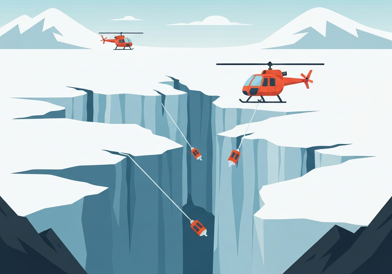
On Feb. 6, 2026, scientists aboard the South Korean icebreaker Araon, operating in the Amundsen Sea, used airborne tactics to sample waters beneath the fractured floating tongue of the Thwaites Glacier. Teams could not reach a half‑mile‑deep borehole through the main ice mass, so they instead lowered sensors into narrow rifts between giant ice blocks from a hovering helicopter. The method—using a remotely operated platform called RIFT‑OX and other lowered instruments—allowed researchers to directly measure warm ocean water that is melting the glacier’s base and accelerating ice loss.
Key Takeaways
- The expedition reported operations from the icebreaker Araon in the Amundsen Sea on , focused on Thwaites Glacier, a major West Antarctic outlet noted for rapid change.
- Crews could not deploy instruments through a roughly half‑mile (≈0.8 km) deep borehole in the glacier’s main mass, prompting airborne alternatives.
- Researchers lowered a suitcase‑to‑toolshed‑sized platform named RIFT‑OX from helicopters into narrow rifts between floating ice blocks to sample sub‑shelf water.
- Thwaites’s floating shelf is breaking into blocks described as as large as convention centers, creating constricted channels that trap sea ice and impede ship access.
- Warm circumpolar deep water is flowing into a deep submarine trough beneath Thwaites, melting the ice from below and increasing the glacier’s seaward speed.
- Airborne lowering of instrumentation provides a portable, remote way to reach constricted or ice‑choked passages that ships cannot enter.
- Field techniques demonstrated on this voyage aim to improve observation coverage where direct ship access and boreholes are impractical.
Background
Thwaites Glacier, located in West Antarctica’s Amundsen Sea sector, is widely regarded by glaciologists as one of the region’s most vulnerable ice masses because of submarine melting and its configuration on a retrograde bed that deepens inland. Ocean‑driven thinning of its floating shelf and grounding zone can destabilize inland ice, with implications for global sea level. Over recent decades, satellite and shipborne observations have shown accelerating ice motion and mass loss in the Amundsen Sea embayment.
Studying the water masses that contact the glacier’s underside is essential to quantify melt rates and to validate models that project future sea‑level contribution. Standard approaches include boreholes drilled from the surface, shipboard CTD casts, and autonomous underwater vehicles; each has operational limits when ice is fractured or channels are too narrow for a vessel. The Araon expedition combined traditional ship operations with helicopter‑deployed platforms to work around these access constraints.
Main Event
The research team initially attempted to reach subshelf waters through a deep hole cut in the glacier but were unable to pass instruments through that particular aperture. With rifts between the floating blocks closed to the Araon and often choked with sea ice, scientists turned to aerial deployment. From a helicopter hovering above a rift they lowered instrumentation on tethers, guiding an unmanned, recoverable platform into tight spaces.
RIFT‑OX, short for Recoverable Ice Fracture Ocean Explorer, was designed to be compact enough to be delivered through a helicopter door and robust enough to operate remotely in turbulent, ice‑filled channels. Operators conducted multiple drops into different rifts on the western side of Thwaites’s ice shelf, collecting temperature, salinity and other oceanographic profiles aimed at characterizing the warm water incursions melting the shelf from below.
Observers reported that the glacier’s floating front is fragmenting into very large tabular blocks—some compared in size to convention centers—leaving narrow, irregular passages. These constricted waterways funnel circumpolar deep water into sub‑shelf cavities and complicate conventional ship access, which motivated the aerial tactic during this field season.
Analysis & Implications
Reaching subshelf waters is a technical and logistical challenge but critical to constraining the processes that control Thwaites’s mass balance. Direct measurements of temperature and salinity in the rifts help determine the heat available for basal melt, informing models of grounding‑line retreat. If warm water transport into these troughs continues or intensifies, it will sustain elevated basal melt rates, potentially increasing ice discharge into the ocean.
The helicopter‑lowered approach expands observational reach in fractured shelf environments where ships and conventional autonomous vehicles face limits. By making deployments more portable, teams can sample multiple rifts across a broad front in a single season, improving spatial resolution of ocean forcing. However, data from a single campaign cannot yet resolve year‑round variability in water properties or the full temporal evolution of melt rates beneath the shelf.
From a risk perspective, Thwaites plays an outsized role in projections of Antarctic‑driven sea‑level rise. Improved sub‑ice observations reduce uncertainty in model projections and help policymakers and coastal planners assess timelines for possible impacts. But operationalizing these airborne deployments at scale will require more testing, logistics planning, and integration with satellite and model efforts.
Comparison & Data
| Feature | Reported Measurement / Description |
|---|---|
| Deep borehole attempt | Approximately half‑mile deep (≈0.8 km); instruments could not be passed |
| RIFT‑OX size | Described roughly as the size of a toolshed, designed for helicopter lowering |
| Ice‑block dimensions | Fragments compared to convention centers (qualitative) |
| Operating platform | Icebreaker Araon in the Amundsen Sea; helicopter deployments from ship |
The table summarizes operational constraints and the tools used on this voyage. While depth and qualitative size descriptors come from field reporting, quantifying melt in volumetric terms requires combining these point measurements with broader hydrographic surveys and numerical models.
Reactions & Quotes
“They did it ‘Mission: Impossible’ style, leaning out of a helicopter in midair.”
Expedition report, field narration
“Lowering a recoverable platform into narrow rifts offers access where ships cannot go,”
Field researchers (reported)
Field scientists and polar researchers outside the expedition noted that novel deployment methods are necessary to close observation gaps, while urging systematic, repeated sampling to capture seasonal and interannual variability. Funding agencies and program managers, observing the technique, may weigh its cost‑effectiveness for future campaigns.
Unconfirmed
- Long‑term performance: It is not yet established whether RIFT‑OX deployments will provide sustained, year‑round coverage or how frequently recoverable platforms can be redeployed in severe weather.
- Net melt quantification: Point measurements from rifts do not by themselves determine the total contribution of Thwaites to current sea‑level rise without integration into broader surveys and models.
- Scalability: The logistical, cost and safety implications of routine helicopter‑deployed sampling across multiple sectors of Antarctica remain to be demonstrated.
Bottom Line
The recent Araon expedition demonstrated a pragmatic workaround for a fundamental observational problem: accessing subshelf water in heavily fractured, ice‑choked margins. Helicopter‑lowered platforms like RIFT‑OX can reach narrow rifts that ships cannot, delivering critical temperature and salinity profiles needed to assess basal melt processes at Thwaites Glacier.
These measurements improve our physical understanding and help reduce uncertainties in projections of Antarctic contribution to sea‑level rise, but they are one piece of a larger observational and modeling effort. Sustained, repeatable campaigns and integration with satellites and numerical models will be essential to translate these technical advances into more confident forecasts for coastal planners.