
Lead
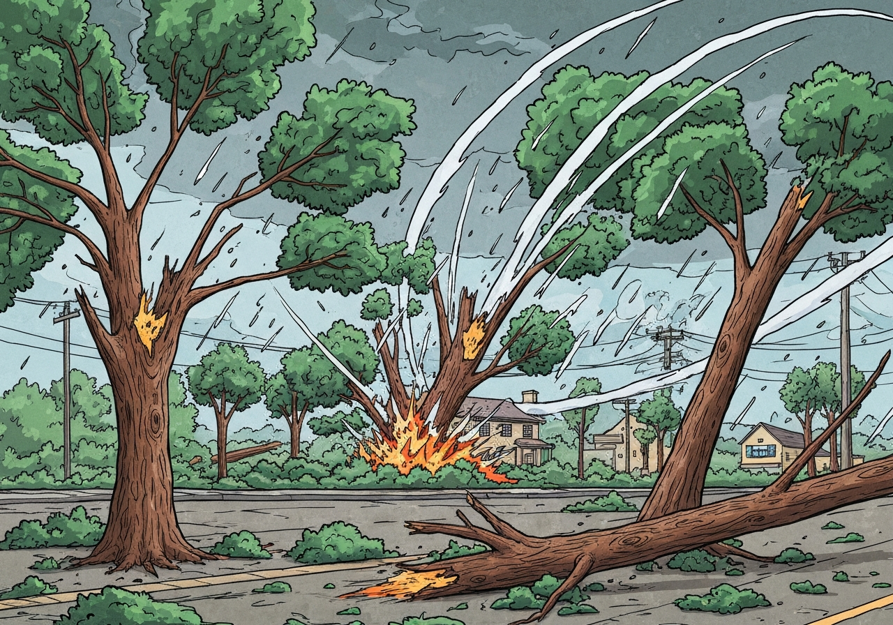
On Monday morning, severe storms swept through the Charlotte area, and the National Weather Service confirmed an EF-0 tornado with 85 mph winds struck a northeast Charlotte warehouse, ripping off its roof. The tornado traveled roughly 1.5 miles, touched down southwest of the structure and lifted shortly beyond it. Authorities reported no injuries at the site, though trees and property around the path sustained damage and thousands experienced power outages. Local meteorologists had flagged the storm with high confidence before the NWS survey concluded.
Key Takeaways
- The National Weather Service confirmed an EF-0 tornado with estimated peak winds of 85 mph hit a northeast Charlotte warehouse on Monday morning.
- The tornado’s damage path was about 1.5 miles long; the touchdown occurred southwest of the warehouse and lifted just past the site.
- No injuries were reported in the NWS survey of the affected area.
- Damage to the warehouse included a ripped roof; outside the building, tree damage was the most common impact.
- Storm reports and a tornado warning coincided in time and location, matching the damage survey findings reported by local meteorologists.
- Across the Charlotte area, more than 4,000 Duke Energy customers were without power as of 11:20 a.m.; statewide outages exceeded 7,500 customers.
- In southeast Charlotte, a large tree fell onto a home near Sardis Road and Guilford Court around 10 a.m.; the homeowner and her dog were reported to be safe.
Background
Charlotte and the broader Piedmont region routinely face severe convective storms in spring and fall, producing damaging straight-line winds, hail and occasional tornadoes. Urban tree canopies, older residential lots and some industrial roofing systems are particularly vulnerable to high winds, which increases the likelihood of property damage even in lower-rated tornadoes. Local broadcast meteorologists, including WCNC’s team, closely track radar signatures and public reports to provide near-real-time guidance during outbreaks.
The Enhanced Fujita (EF) scale, used by the National Weather Service, rates tornadoes primarily by observed damage, correlating that damage to estimated wind speeds. EF-0 events have winds from 65 to 85 mph and can uproot trees, peel roof coverings and cause light structural damage. Municipal emergency managers, utilities and first responders coordinate restoration and safety checks after these events to clear hazards and restore services.
Main Event
Monday’s line of storms produced a tornado that NWS survey teams classified as EF-0, with an estimated maximum wind speed of 85 mph. Survey crews mapped a damage path of about 1.5 miles, noting the touchdown southwest of the warehouse and that the circulation lifted just beyond the site. The warehouse sustained significant roof damage, but survey notes indicated damage outside the building was limited primarily to downed and sheared tree tops.
Local meteorologist Brad Panovich reported receiving multiple damage calls around 10:30 a.m. in the Atando Avenue area of northeast Charlotte and assessed a high likelihood of tornadic damage before the NWS confirmation. Panovich and colleague Chris Mulcahy identified a contiguous trail of damage on the ground that aligned with a radar couplet and the tornado warning issued for the area. That alignment of warnings, radar signatures and ground reports helped confirm the presence of a brief tornado.
Elsewhere in the city, storms felled a large tree in southeast Charlotte near Sardis Road and Guilford Court around 10 a.m. Neighbors reported the tree fell onto a home; the resident and her dog were reported safe because she was not home at the time. Utilities crews began responding citywide as outages were reported in multiple neighborhoods, prioritizing hazardous downed lines and areas affecting critical facilities.
Analysis & Implications
Even low-end EF tornadoes like this EF-0 can cause disproportionate localized damage where structures or trees are vulnerable. A torn roof on a warehouse can disrupt business operations, displace inventory and trigger insurance claims that take weeks to resolve. For residents, fallen trees present immediate safety hazards and can lead to costly repairs; removal and insurance processing often become the dominant short-term tasks after the storm clears.
Power outages affecting several thousand customers increase risks to people who depend on electrified medical equipment and can interrupt traffic signals and other infrastructure. Utility restoration timelines depend on the scale of damage and availability of crews; Duke Energy’s interactive outage map indicated at least 1,000 customers were without power in Montibello and projected some restorations by 6 p.m., while the company reported over 7,500 statewide outages as of 11:20 a.m.
From a preparedness perspective, the event highlights the importance of timely warnings and public response. Forecasters and broadcasters that issued tornado warnings and flagged the radar couplet likely reduced exposure by prompting people to seek shelter. Municipal inspections of damaged structures and trees will determine whether further closures or hazardous-material precautions are needed.
Comparison & Data
| EF Rating | Estimated Wind Range | Typical Damage |
|---|---|---|
| EF-0 | 65–85 mph | Minor roof and siding damage; branches broken; shallow-rooted trees uprooted |
| EF-1 | 86–110 mph | Moderate roof damage; mobile homes overturned; more significant structural issues |
The National Weather Service classified the Charlotte event at the top end of EF-0 (85 mph), immediately below the EF-1 threshold of 86 mph. That single-mph distinction illustrates why surveyors focus on damage indicators and construction quality when estimating winds. In urban settings, debris and tree fall patterns often provide the clearest evidence to distinguish between EF-0 and borderline EF-1 damage.
Reactions & Quotes
Local meteorologists and residents reacted quickly as reports came in; their statements provide context for both the warning process and on-the-ground impacts.
“I would tell you with almost 99% certainty that we had a tornado touch down in this area,”
Brad Panovich, Chief Meteorologist, Weather Impact
Panovich had been collecting damage reports in northeast Charlotte and pointed to sheared tree tops and a visible damage path as evidence aligning with tornadic winds. His on-air assessment preceded the NWS survey, and his team cited radar couplets and spotter observations as supporting information.
“This all looks like tornado damage to me,”
Brad Panovich, Chief Meteorologist, Weather Impact
Panovich and meteorologist Chris Mulcahy noted that ground reports line up with the tornado warning that had been issued during the storm’s passage. Those comments emphasized that multiple independent indicators — radar, warnings and physical damage — converged on the same conclusion.
“We are OK — thankfully I and my dog were not home when the tree fell,”
Homeowner, Sardis Road area (reported to WCNC)
The homeowner’s remark underscores the personal risk posed by falling trees; in this case the resident and pet were reported safe, but the incident required emergency response and later property repair.
Unconfirmed
- Early on-air assessments suggested the damage could be borderline EF-1; the NWS survey classified the event as EF-0, and any change would require further official reassessment.
- Precise counts of downed trees and the total monetary cost of property and business losses have not yet been confirmed by officials.
- Exact restoration timelines for all customers are tentative and depend on evolving assessments of damage and crew availability.
Bottom Line
Monday’s severe storms produced a brief but damaging tornado in northeast Charlotte that the National Weather Service ranked as an EF-0 with 85 mph winds, causing a ripped warehouse roof, tree damage and localized power outages. No injuries were reported, which emergency managers cite as a crucial outcome given the potential for harm in urban tornado events. The alignment of warnings, radar signatures and ground reports demonstrates effective forecasting and situational awareness, though the incident highlights continued vulnerability of trees and some building types to convective wind events.
Residents and businesses should expect continued utility restoration work, municipal inspections and insurance assessments in the coming days; officials will publish updates as surveys and repairs proceed. For the public, the episode reinforces the value of heeding tornado warnings, identifying safe shelter locations ahead of storms and securing outdoor hazards when severe-weather threats are forecast.
Sources
- WCNC Charlotte (local news report)
- National Weather Service (official federal weather agency)
- Duke Energy Outage Map (utility outage information)