
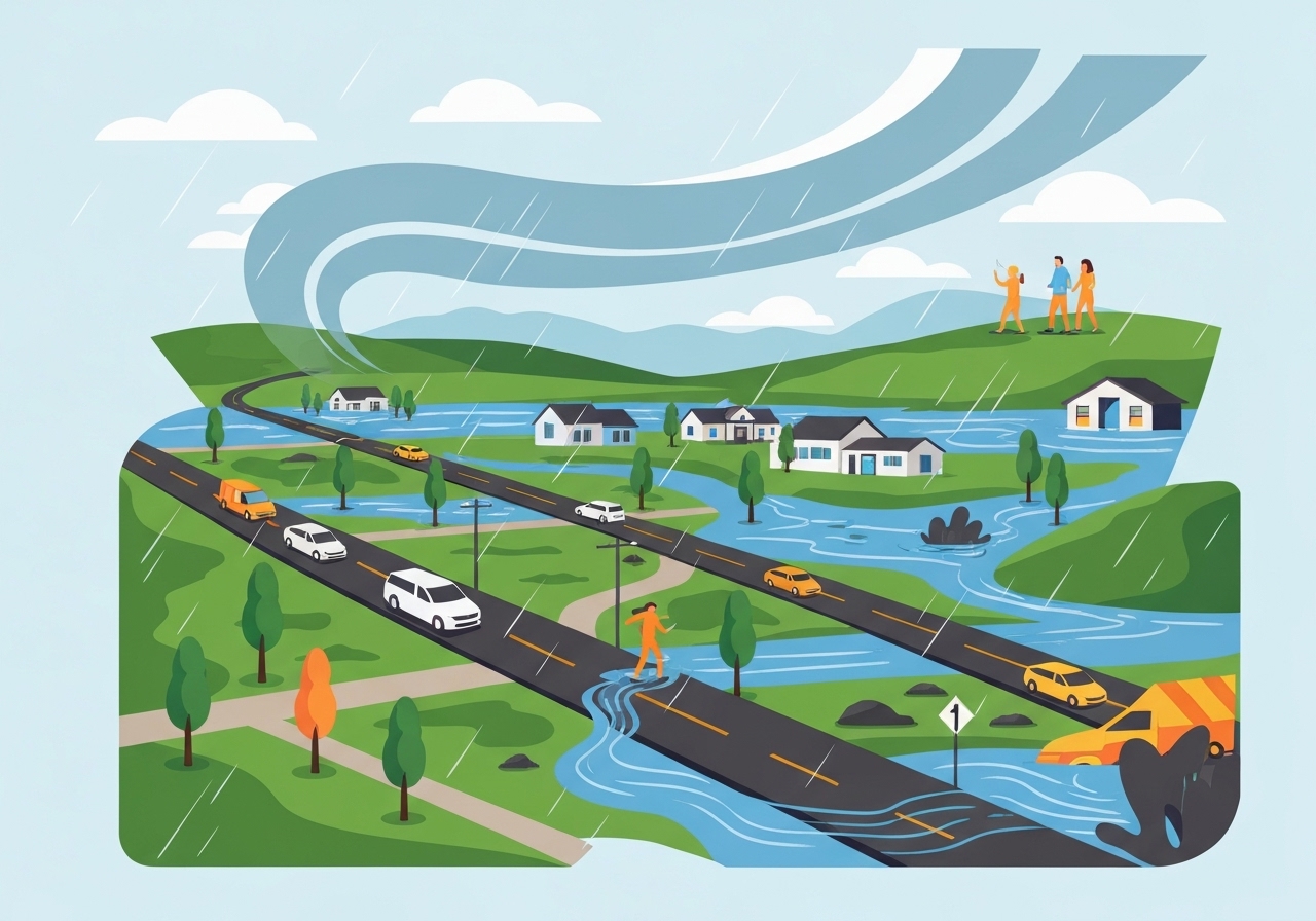
Lead: A section of the Desimone levee on the Green River east of Seattle-Tacoma International Airport breached around noon local time on Monday, forcing evacuations in Tukwila and nearby communities as a renewed atmospheric river drenches the Pacific Northwest. The levee protects more than 30,000 residents in Tukwila, Kent and Renton; a flash-flood warning covered roughly 45,000 people in the immediate area. River levels had climbed about 15 feet over the previous week and were just under 22 feet at the time of the breach — the highest in roughly 60 years. Officials urged residents to avoid the area and evacuate while emergency teams assess damage and flood paths.
- The Desimone levee in Tukwila failed at approximately 12:00 p.m. local time on Monday, exposing communities that the structure was designed to shield (Tukwila, Kent, Renton; population protected: >30,000).
- A flash flood warning covered an estimated 45,000 people as river levels rose and overflow risk intensified across the Green River corridor.
- The Green River rose about 15 feet over the prior week due to an earlier atmospheric river; measured stage was just under 22 feet at the breach, the highest in roughly 60 years.
- King County crews had installed a seepage blanket last week as an emergency stabilizing measure ahead of the renewed rains.
- Monday’s storm affected parts of Washington, Oregon and far northwestern California, producing renewed river rises and increased landslide risk in steep terrain.
- Meteorological forecasts project a second, colder atmospheric river Tuesday through Wednesday and a likely third storm by Thursday, keeping rivers elevated and complicating recovery.
Background
The Green River corridor southwest of Seattle is a long-populated and industrially active valley that depends on levees, floodplains and other engineered controls to reduce flood risk. The Desimone levee is one of the primary flood-risk reduction structures protecting residential and commercial areas near Tukwila and downstream cities; local authorities have repeatedly reinforced levees in recent years as extreme precipitation events have become more frequent. Flood-control infrastructure across western Washington was already under strain after an earlier atmospheric river last week sent several rivers to record or near-record levels.
Atmospheric rivers — long, narrow corridors of intense moisture transport from the subtropics — routinely supply a large share of the region’s wet-season precipitation. When multiple systems arrive in quick succession, soils saturate, rivers rise and engineered defenses can be overwhelmed. King County and state agencies have issued advisories and pre-positioned equipment in recent days, but the scale and timing of sequential storms complicate both preventive work and emergency response.
Main Event
The levee breach occurred near noon Monday east of Seattle-Tacoma International Airport, in the portion of the Green River that flows through Tukwila. Officials reported that the structure had been subject to seepage concerns and that crews had installed an emergency seepage blanket the prior week to help stabilize the bank. Despite that measure, fast-rising flows from sustained heavy rain overwhelmed the levee at high stage.
Emergency managers issued evacuation orders and urged people to avoid low-lying areas around the river. First responders focused on life-safety tasks: warning residents, closing vulnerable roads and establishing temporary shelters. Officials also worked to map the flow path and determine where water would pond or overtop secondary defenses.
By mid-afternoon, rivers across the region were again rising as additional precipitation moved inland. Mountain slopes that had already absorbed significant rainfall saw renewed landslide threats, and wind gusts associated with the incoming storm raised concerns about downed trees and power outages. Local utilities and road authorities announced precautionary closures and posted situation updates as conditions evolved.
State and county agencies described the situation as an active emergency with response operations ongoing. Assessments of structural damage, infrastructure impacts and the geographic extent of inundation were in progress and likely to change as crews gained access and water levels shifted.
Analysis & Implications
The breach highlights the vulnerability of 20th-century flood infrastructure to 21st-century weather extremes. Levees are designed for certain return-period flows, but sequential atmospheric rivers and very high antecedent moisture can push systems beyond those design thresholds. In this case, repeated heavy precipitation produced an unusually high base flow — the Green River rose roughly 15 feet in a week — leaving little margin for the next storm system.
Operationally, consecutive storms complicate emergency management. Response resources and volunteer capacity were already taxed by last week’s flooding, limiting the speed of preventive reinforcement and post-event recovery. Repair timelines for a major levee breach can span weeks to months depending on access, sediment deposition and the need for environmental permitting; meanwhile, downstream communities remain at higher short-term risk until flows recede and temporary measures are installed.
Economically and socially, repeated flood events create cascading impacts: disrupted supply chains, displaced residents, stranded workers and pressure on local budgets for repairs and disaster assistance. Insurance penetration varies across the region, so individual households and businesses may face significant out-of-pocket losses, while local governments manage emergency shelter, debris removal and infrastructure repairs.
Comparison & Data
| Metric | Most recent | Week prior | Historical context |
|---|---|---|---|
| Green River rise | ~15 ft increase over 7 days | N/A | Highest stage in ~60 years (~22 ft at breach) |
| Population under warning | ~45,000 people | N/A | Levee protects >30,000 residents in three cities |
| Atmospheric river timing | Current (Monday), second Tue–Wed, possible third Thu | N/A | Multiple ARs in <7 days |
These figures show why emergency managers emphasized evacuation and access restrictions: a rapid multi-day build-up in river stage combined with successive atmospheric rivers reduced time and options for protective operations. Historical stage comparisons place the current water level among the highest recorded in several decades, explaining the elevated failure risk for flood defenses.
Reactions & Quotes
Local emergency authorities issued direct instructions to residents as water encroached on critical infrastructure and neighborhoods. The tone was urgent and focused on immediate safety.
“We are asking the public to avoid the area and people in the area to evacuate,”
King County Office of Emergency Management (official statement)
King County Department of Natural Resources described the emergency measures taken in recent days to bolster the levee and contextualized the breach within ongoing stabilization efforts.
Crews “installed an emergency flood fighting measure called a seepage blanket to help stabilize the levee” last week,
King County Department of Natural Resources (official)
Unconfirmed
- Extent of structural damage to homes and commercial properties adjacent to the breached levee remains under assessment; estimates of economic loss are not yet available.
- Final, validated causation for the levee failure (for example, overtopping vs. seepage vs. structural failure) has not been publicly confirmed pending engineering inspections.
- Precise timelines for repairs or full containment of flooding are not yet determined and depend on river stage forecasts and permitting for reconstruction.
Bottom Line
The Desimone levee breach on the Green River amid a renewed atmospheric river has created an acute local emergency with broader implications for flood resilience across western Washington. With river stages at their highest in roughly six decades and two additional storm systems likely within days, short-term risks to life, property and infrastructure remain elevated.
Authorities and residents should treat evacuation orders and warnings as mandatory for safety; recovery and repair work will follow only once water levels fall and structural assessments are complete. In the longer term, this episode reinforces the need to reassess flood defenses, land-use practices in floodplains and regional preparedness in a climate where intense, repeated precipitation events are becoming more common.
Sources
- CNN (news) — original reporting on the levee breach and regional storm impacts.
- King County Department of Natural Resources and Parks (official) — statements on seepage blanket installation and emergency stabilizing measures.
- National Weather Service (official forecast) — regional forecasts and atmospheric river outlooks that informed timing of follow-on storms.
- Washington State Emergency Management Division (official) — statewide situational awareness and emergency resources.